BONE
BASIN, SOUTH CELEBES
Sulawesi (Celebes) Island is
one of the five largest islands in the Indonesian archipelago, having a
distinctive shape like the letter "K". Sulawesi Island is located in
an area with complex tectonics in the meeting zone between the Eurasian,
Indo-Australian and Pacific plates (Hamilton, 1979; Silver et al., 1983).
Sulawesi Island is
formed from a tectonic zone that traverses north-south (Sukamto, 1975). The
zones are started from west to east namely West Sulawesi Tertiary Volcanic Bow,
Minahasa-Sangihe Quaternary Volcanic Bow, Central Sulawesi Cretaceous-Paleogene
Metamorphic Path, East Sulawesi Cretaceous Ofiolite Path and association of
cover pelagic sediments and continental micro fragments of the Paleozoic
continent originating from the Plate Continent of Australia). Contact between
these tectonic provinces is large faults (Figure 2).
In the northern part
of the island of Sulawesi there is a Trench in North Sulawesi formed by
subduction of Sulawesi's oceanic oceanic crust, while in the southeast part of
Sulawesi there is a Tolo Fault triggered by subduction between the southeast
arm of Sulawesi Island and the northern Banda Sea, where the two main
structures are connected by Palu fault -Koro and Matano In the western part of
Sulawesi there is the Makassar Strait that separates the western arm of
Sulawesi with the Sunda Bow which is part of the Eurasian plate which is
thought to have formed from the expansion of the ocean floor in the Miocene
period, while in the east there are continental fragments which move from
sliding faults New Guinea (Hall and Willson 2000, in Armstrong, 2012).
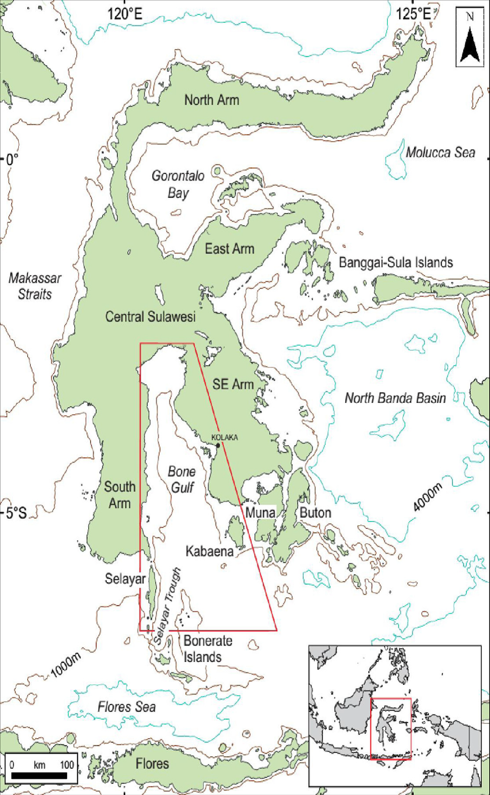
Location of Bone
Basin, Sulawesi (modification from Camplin and Hall, 2014).
The Bone Basin is
located in the Gulf of Bone (Figure 1), where the western and eastern parts are
limited by the Arm of West Sulawesi and the Arm of East Sulawesi, the northern
part is bordered by Central Sulawesi and the southern part is bordered by the
Java Sea. Bone Bay covers an area of about 30,000 square kilometers. The
water depth in Bone Bay ranges from 200 to 3,000 meters. The Bone Basin is cut
by several faults such as; The Palu-Koro Fault, and the Walanae Fault, and
flanked by two heights namely Bonerate high in the west and Kabaena high in the
east, resulting in various types of rocks mixed so that the stratigraphic
position becomes very complicated.
In 2011 the Marine
Geological Research and Development Center (P3GL) conducted geological and
geophysical surveys in the waters of the Gulf of Bone (Figure 1) using the
Geomarin III Research Ship (Sarmili, 2011). The main focus of this paper is to
interpret the sedimentation process in Bone basins based on reflected seismic
data. The difference in the reflector character in this reflective seismic will
be interpreted as a reference for any type of sediment and its stratigraphic
relationship in the deposition process.

Sulawesi Geological
Map (Hall and Wilson, 2000)
Bone Basin is divided
into 6, (six) rock units according to Yulihanto (2004), namely claystone unit
A, limestone unit B, volcanic rock unit C, limestone unit D, sandstone unit E
and the youngest unit sediment filler F (Channel-filled sediment) .
Sequence A is equated
with claystone which is the lowest sequence of the Bone basin and has the
oldest age based on the appearance of the Malawa Formation in the Western Arm
and the pelagic and ofiolite sediments in the East Arm in the proportional
column (Figure 12), ie aged Eocene with this unit thickness reaching 450 meters
with a depth of around 3986 meters below sea level.
Sequence B is equated
with Limestone which is estimated to represent units from the Tonasa Formation
and the Oligocene Tampakura Formation (Figure 11) with a thickness of variation
reaching 900 meters with the deepest depth around 3407 meters below sea level.
In this sequence, a basin with an elongated shape with a wider southern part
than the northern part is seen.
Sequence C is equated
with Volcanic Rocks (Figure 12) which are units representing the Camba and
Molasa Formations of Sulawesi Langkowala Formation (lower to middle Miocene).
In this basin there are several sediment thicknesses which reach 200 meters
with a depth of about 3114 meters below sea level.
Sequence D which is
equated with Limestone (Figure 12) represents the Tacipi Formation and belongs
to the Sulawesi Molasa Eemoiko Formation which is middle Miocene. Has a
sediment thickness of up to 700 meters. with a depth of about 3021 meters below
sea level. This sequence forms a longitudinal basin with a north-south
direction, where as the northward direction, the sediment is getting shallower
and vice versa the southern direction the sediment gets deeper.
The Sandstone E Unit
represents the deposits of the Walanae and Molasa Formations of Sulawesi. This
unit has a thickness of up to 1000 meters at depths reaching 3278 meters below
sea level. In this sequence there are also Quaternary basins which are at the
top of the sequence and filled with new deposits. This sequence morphology has
an elongated oval shape with the deepest part in the south and shallow in the north.

Bone Basin
Stratigraphy
Neogen
History of the Bone Basin
Gulf Bone has a
complex history of formation in Neogene times, this formation is dominated by
extension processes. The basic rocks of Bone Bay do not originate from the
oceanic plate, but from some pre-Neogenous rocks. In the west it is composed of
volcanogenic rocks, in the north composed of low-level and ofiolite metamorphic
rocks, and in the east is composed of metamorphic and ultramafic rocks.
Basins began to form
in the Early Miocene, the age of rock units also showed that the extension
process began in the Middle Miocene even though the explosion had begun since
the Early Miocene. Bone Bay is divided into several sub-basins and heights.
Tinggian in the Gulf of Bone is a reflection of the shear fault zone which runs
west west northwest-southeast. The direction of the shear fault is influenced
by the bedrock structure, the active time of the shear fault also varies. The
shear fault zone associated with Tinggian Basa has been active since the
beginning of the basin formation, while the shear fault zone associated with
Tinggian Kolaka has a younger age. This is evidenced by the movement in the
Kolaka Fault which is on land in the Late Miocene to the Pliocene.
Faults that limit the
sub-basin have an orientation north-west-south-southeast. These faults have striking
vertical components so that they can be indicative of horizontal shifts. One of
the faults is the Walanae Fault found in South Sulawesi and continuously up to
Selayar Palung. The fault has been identified as a sliding fault, this is
accompanied by a vertical component which is also found in Selayar Trench.
The sediments found
in Bone Bay originate from the north, east and west of the basin. At the
boundary of the basin there are carbonate deposits which are associated with
deep sea deposits found in the center of the basin. The inconsistency between
Unit D and E with the unit of rock above becomes a sign when Sulawesi Island
undergoes a lift while at the same time Bone Bay experiences displacement.
Movements in the Walanae Fault Zone and Bonerate Fault Zone cause inversion and
leverage in the basin. These events caused siliciclastic sediments from the
northern basin to enter the Gulf of Bone, this was followed by the formation of
the southern-leading Bone Gorge, formation of exposure to carbonate rocks which
showed a form of drowning at the edge of the basin, and back-stepping carbonate
rocks.
References:
- Armstrong, F. S., 2012. Struktur Geologi Sulawesi. Institut Teknologi Bandung.
- Bemmelen, R.W.V., 1949, The Geology of Indonesia, vol. I A, Government Printing Office, The Hague.
- Camplin, D.J. dan Hall, R. 2013. Insight into the Structural and Stratigraphic Development of Bone Gulf, Sulawesi. Proceedings Indonesian Petroleum Association, 37th Annual Convention and Exhibition May 2013.
- Darman H., dan Hasan F. S., 2000. An Outline of The Geology of Indonesia, Published by IAGI- 2000, h. 101-120.
- Hamilton, W.H., 1970. Tectonic Map of Indonesia.USGS, Denver, Colorado.
- Lili Sarmili et. al., 2016, PROSES SEDIMENTASI CEKUNGAN BONE BERDASARKAN PENAFSIRAN SEISMIK REFLEKSI DI PERAIRAN TELUK BONE SULAWESI SELATAN, JURNAL GEOLOGI KELAUTAN Volume 14
- Sudarmono, 1999. Tectonic And Stratigraphic Evolution Of The Bone Basin,Indonesia: Insights To The Sulawesi Collision Complex. 27thProceedings, IPA Oktober 1999.
Tidak ada komentar:
Posting Komentar